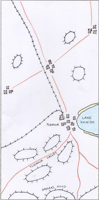
The table sizes are not to scale.
Here are some indications of what each table might look like. The availability of terrain will influence this, in both directions; if we can't build a table that way for lack of suitable terrain pieces, we won't. If we get a particular terrain piece that just begs to be used, we will.
Table 1- Caucasus Front covers the trenches of the Caucasus Front where the Turks and Russians have been fighting for years. Now only Andreivian (and perhaps Armenian) forces stand in the way of a Turkish breakthrough.
Table 2 - Black Sea Coast covers the western side of Andreivia, in particular the Black Sea coast:
Designed with a couple of story seeds in mind, this table needs a fair amount of dedicated terrain but I'm sure we can do it.
Table 3 - Tcherbevan covers dear old Tcherbevan and surrounding districts. I haven't at this stage tied the village names and locations back to the 1990s map but this can be done at our leisure.
And then there's Table 4 - Eastern Andreivia. This represents the whole of eastern and southeastern Andreivia heading down to the border with the short-lived Republic of Mountainous Armenia (look it up: it really existed).
Table 5 is the special table. On Saturday morning it represents the National Museum of Andreivia. Who knows what it might represent at other times!


5 comments:
Seems the coast is clear for me to attend, Hurra!!!
Hurrah indeed!
These look good Richard. The Caucasus table might be a bit of a blood bath.
Cheers, Andy
Andy,
You're right. Realistically the Turks should break through on the Caucasus Front with the departure of the Russians. Depending on what Turks Will can provide we may have to recycle them until a breakthrough does occur.
I've just realised that we need to include Vani somewhere; probably top end of the Eastern Andreivia table.
Post a Comment